Lake Michigan Shorelands Alliance

The Lake Michigan Basin
Protecting Wisconsin's Coastal Resources

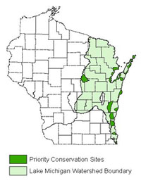
The watershed of Lake Michigan extends through all or part of more than thirty counties in Wisconsin. From Chiwaukee Prairie near the Illinois border to Washington Island off the tip of the Door Peninsula, the coastal resources of eastern Wisconsin represent some of the most scenic and ecologically valuable lands in the state. These coastal sites are only as healthy as their watershed, and planning for future conservation requires a strategic regional perspective for the entire Lake Michigan Basin of Wisconsin.
Ecological Significance
The Lake Michigan Basin supports a unique and impressive array of biological diversity, including many species that occur nowhere else in the world. The sand dunes, coastal marshes, tall grass prairies, savannas, forests, and fens all provide important habitat for this diversity of species.
The waters of the Lake Michigan Basin are also crucial, both for wildlife and as resources for human use. Thousands of miles of streams and rivers drain to the lake, creating valuable and vulnerable riparian corridors. Lake Michigan itself, as the second largest Great Lake, supports a large commercial and sport fishery and provides drinking water and recreation to many communities.
Potential Threats
This watershed is developing rapidly as the urban areas in southeastern Wisconsin spread northward and recreational pressure grows in areas such as Door County. Poorly planned development could permanently alter the watershed, destroying vital habitat and damaging the water quality of Lake Michigan and the streams and rivers that feed it. Another pressing threat is the spread of a variety of invasive species, from gypsy moths to purple loosestrife, which degrade natural habitat and harm native species.

Current Activities
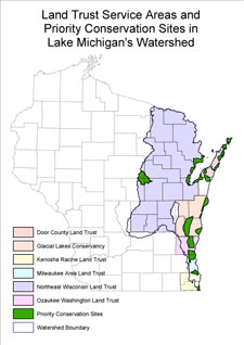
The Lake Michigan Shorelands Alliance (LMSA) is a collaborative group of land trusts and conservation organizations working to protect land and water resources in the Lake Michigan Basin. The Alliance was formed in 2003, and has undertaken strategic conservation planning for the Lake Michigan Basin watershed region. The Alliance has identified eighteen Priority Conservation Sites, which will be the focus of further conservation work.
Root River Riverine Forest
A Forest Oasis

The Root River Riverine Forest and the associated natural areas border the Root River in southern Milwaukee and northern Racine counties. This site is composed of stands of mesic hardwood forest and floodplain forest. As one of the few remaining forest blocks in the region, it provides habitat for a wide variety of plant and animal species. The MALC currently is the main group that will look for a better natural future for the Root River.
Ecological Significance
This site is important because it is one of the few remaining high-quality forested sites in coastal southern Wisconsin. The forests found at this site provide important stopover habitat for migrating birds and also harbor numerous resident species, including eight rare species of plants. The American Gromwell, Bluestem Goldenrod, and Heart-Leaved Skullcap are only a few of the rare species that have been observed in the Root River Riverine Forest in the past few years.
This forest also provides a valuable buffer to the Root River, an important recreational and angling resource which passes through extensive developed areas. This buffer improves water quality and decreases the potential for flooding by absorbing storm-water runoff.
Potential Threats
The greatest threat to this forest fragment is encroaching development from the nearby urban area of Racine. The site, as a remnant natural area also faces the challenges of maintaining viable populations of important species in a small and isolated area.
Current Activities
Root River Riverine Forest has been identified as a Priority Conservation Site by the Lake Michigan Shorelands Alliance (LMSA). The Wisconsin Department of Natural Resources has an established project at this site, and will be working with partner organizations to develop a comprehensive site conservation plan.
